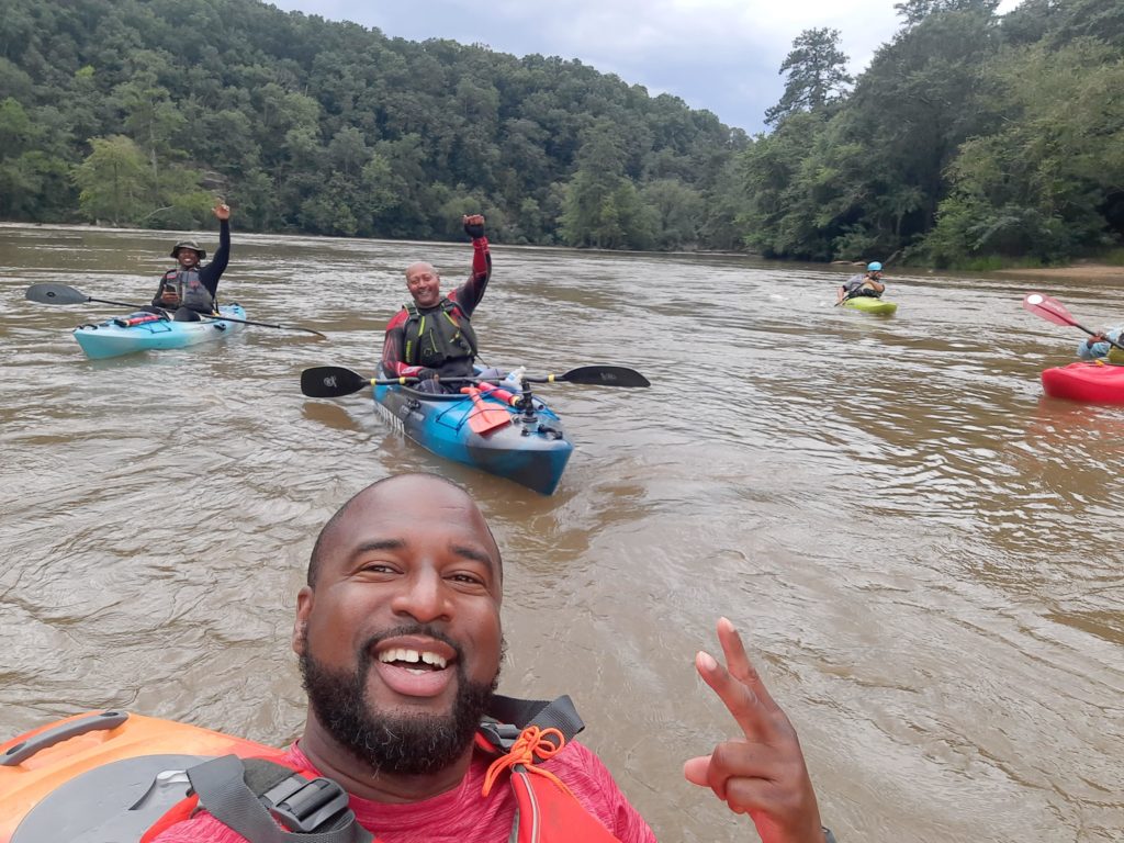
Many of us have heard the phrase “up the creek without a paddle,” but that is not a place you want to be. North Georgia is every river rat’s dream with local access to the Chestatee, Chattahoochee, Chattooga, Nantahala, Etowah and Toccoa rivers. Beautiful rushing rivers, pristine lakes, magnificent waterfalls and cinematic trout streams provide a gateway to adventure for paddlers, hikers and sportsmen.
Canoes, kayaks, stand up paddleboards and tubes offer opportunities for everyone to get out on the water. With so many options to put in and paddle, I decided to learn the ropes with some local experts.
Where to Dip your Paddle
Wondering where to get started on your kayaking adventure can be a little daunting for the newbie. Fortunately, author and adventurer Joe Cook wrote the book on Georgia rivers. In fact, Cook wrote five Georgia River User Guides to the Chattahoochee, Etowah, Broad, Flint, Oconee and Ocmulgee rivers. When asked about his favorite place to paddle, Cook said “Asking for a favorite paddle journey is like picking your favorite child. It can’t really be done.” But keeping North Georgia Living readers in mind, Cook eventually submitted South Chickamauga Creek as a top choice.
“It flows through Ringgold and Catoosa County and is an established water trail with developed and designated access points which makes planning a trip easy,” he said. “The creek is full of critters and spectacular limestone bluffs and even has a unique sink hole where a portion of the creek disappears into the ground only to reappear around the next bend a mile or so downstream. The karst geology of the area makes Northwest Georgia known for its caves, but it also creates some interesting creek and river features. South Chickamauga also has some fun shoals and rapids. It really is a beautiful creek and is one of those hidden gems that is just now being discovered. There’s a kayak outfitter in Ringgold that can help you get on the water.”
In addition to South Chickamauga, Cook also recommends the Chestatee River Run, an easy 6 – 7-mile trip for novices. The Lower Etowah River in Cartersville is another great option recommended by the expert author.
Cook also encourages paddlers to protect their freedom to float by documenting their trips on Paddle-a-thon (mightycause.com/event/Paddleathon2024). By participating in this free event, and submitting an online trip report every time you do a river trip, you help document the rivers and streams that Georgians are using. This information is critical in the effort to protect existing river uses.
If a stream does not meet that “navigability” test, Georgia’s existing laws allow property owners along a stream to restrict passage down that stream. Court decisions in the last 30 years have affirmed that navigability test, resulting in streams like Armuchee Creek in northwest Georgia and Ichawaynochaway Creek in southwest Georgia being closed to the public.
A bill introduced during the 2024 session, HB 1397, created a list of “navigable streams” upon which citizens would have the right to boat, fish and hunt. The bill named some 60 streams as “presumed navigable.” Unfortunately, the bill did not include dozens of rivers and streams that Georgians currently use on a regular basis for canoeing, kayaking, paddleboarding and other watersports. Not included in this list were rivers like the Cartecay in Ellijay as well as creeks like Cook’s beloved South Chickamauga. Indeed, about 50 percent of the rivers listed in the guidebook Canoeing and Kayaking Georgia, a leading resource for paddling in Georgia, were not included on the list.
On these “non-navigable” streams, it would take just one property owner to close the stream to the public.
Favorite North Georgia Water Trails
Join a public group like Wild Women Paddling Club of Georgia or Kayak Georgia on social media to get 24/7 advice and access to meetups and information. I did some polling and received an overwhelming response with enthusiastic support for too many paddling places to mention every single one, but here a few tried and true favorites. Etowah River Water TrailThe Etowah River Water Trail stretches 163 miles from Lumpkin County in north Central Georgia to Floyd County in Northwest Georgia, passing through or near the towns of Dahlonega, Dawsonville, Cumming, Canton, Cartersville, Euharlee and Rome. This trail is recommended by such river enthusiasts as Tara Miller Givens, a group expert for Kayak Georgia. “Etowah is a chill paddle with lots of wildlife and a great beach for a lunch break halfway down,” she said. Approximately 156 miles of the river are navigable. The Etowah River Water Trail Stakeholders Group, a consortium of local governments, non-profit organizations, businesses and individuals, is working to coordinate development of the trail by installing information kiosks and maps at established public access points, erecting road signage directing paddlers to access points and assisting local governments with the construction of new public access points. For a complete set of maps of the Etowah River Water Trail and information about upcoming events, visit www.etowahwatertrail.org
Cartecay River to Stegall Mill Trail
The Cartecay River is an intermediate level river near Ellijay on Hwy 52. It has multiple unique river features as well as scenic views for most of the paddle. This river has two paddle sections, Lower Cartecay Road to Stegall Mill Road (aka Blackberry) and Stegall Mill Road to DNR.
Chattooga Wild & Scenic River Water Trail
Wild and Scenic designation keeps rivers in a free-flowing condition by protecting them from bedrock and flow alteration, and development within ¼ mile of the river. The Chattooga River includes calm sections and extreme whitewater, so knowledge of the river’s different sections is advised. Most of the land surrounding the Wild & Scenic Chattooga River Corridor is managed by the US Forest Service. All visitors to the national forests in North Carolina, South Carolina and Georgia wishing to float the upper or lower segments of the Chattooga Wild and Scenic River must carry a self-registration permit at all times. Visitors can pick up a permit free at put-ins along the upper and lower river.
Toccoa River Canoe Trail
The Toccoa River Canoe Trail begins at the Deep Hole Recreation Area in Suches and flows 13.8 miles to the takeout at Sandy Bottoms. This beginner-level trail is perfect for those looking to experience a few rapids and relax amid beautiful scenery. Primary uses of the trail are canoeing, paddling, kayaking and fishing. The cool mountain stream attracts recreation enthusiasts of all interests and is perfect for trout fishing. Enjoy viewing forested public lands, pastoral private lands, laurel and rhododendron thickets, and their associated wildlife.
Upper Chattahoochee River Water Trail
The Upper Chattahoochee River Water Trail is a picturesque waterway that flows approximately 40 miles and is located upstream of Lake Lanier, beginning at the confluence of Sautee Creek and the Chattahoochee in White County and ending at Clarks Bridge Park in Hall County. Its clean, cold waters support diverse aquatic life, and the surrounding forests and hills offer opportunities for outdoor activities. This water trail is a prime destination for kayakers of all skill levels with river classifications ranging from Class I-III depending on water levels. For a wealth of information and resources from Georgia River Network, visit garivers.org.